Today's adventure was a drive through the morning mists into the bright warm sunshine of the San Andreas fault. I've been reading a book called A Crack in the Edge of the World: America and the Great California Earthquake of 1906 which is an amazing mix of geology text and history (for example, it includes an aside that our alleged President's great-great grandfather was once rector of San Francisco's Grace Church, which was later destroyed in the quake). It focuses a bit on the middle-of-nowhere town of Parkfield, epicenter of the 6.0 magnitude 2004 quake. Apparently there are tremors almost all the time, and it is the most seismically monitored site in the world, with a USGS station there.
So I decided to go see for myself. I figured if the weather was okay (it was) Christmas would be an easy drive down 101 and into the hills. It took me about 10 minutes to get through San Jose, at 9:45 am, which would have taken an hour or more on a normal Monday. I was doing my usual 65mph + about 10%, which comes out to 69. I 69ed my way most of the way (except for a stretch which had a 70 mph speed limit), and cars were passing me like I was standing still.
I haven't been on 101 south of Gilroy ever, I don't think. Usually if I'm heading that far south I'm on Amtrak or I-5. The road degrades into a poorly maintained 2-lanes in each direction non-freeway for quite a while, but stays at 65mph, then slows to 55 for a stretch, then to 65 and 70. It's a little over 150 miles to the San Miguel turnoff, and then about 30 miles of back roads to Parkfield. Most of that was safe at 50 mph, give or take 5. Leaving 101, the road starts climbing into the hills, with a steep rise toward the end.
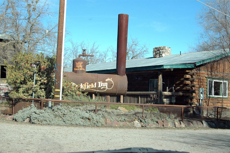
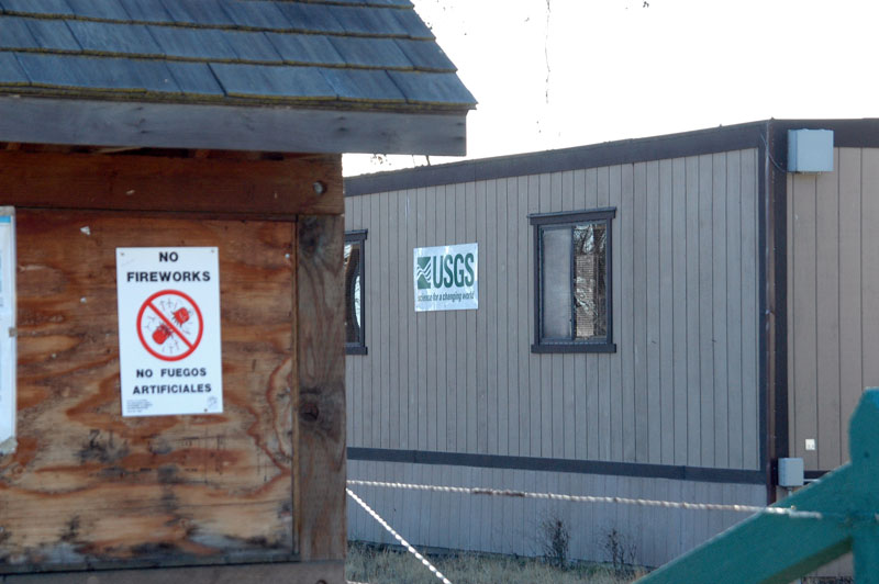
I didn't need a map to get from 101 to Parkfield - there are clearly posted signs at every needed turn. I guess they get a lot of important visitors. It's a tiny town, just a few homes, a school, the USGS cluster of puke-green buildings, a log cabin inn and a log cabin cafe (both deserted today).
But I'm getting ahead of myself.
At 1:30 pm, 4 hours after leaving home, I arrived at the fault line.
Parked the car, propped the camera up (I'd forgotten to bring a tripod) and posed.
Got back into the car, drove across the bridge and posed again.
Fifteen minutes later I was in scenic Parkfield.

There is a little park behind the inn, I walked around, ate an apple, and watched to yuppie motorcyclists take way too long to figure out the cafe was closed, then hopped back in the car and continued on Parkfield-Coalinga road, hoping to go to Coalinga and then hook up to I-5 for a faster return on a better freeway. But about two miles down the road the pavement ended and there was a scary sign saying the road is impassible when it's wet. It was 75 degrees and sunny, but rain was in the forecast, and I decided not to do a Kim Family Outing, and drove back to 101 instead. But along the way to the end of the paved road, I saw this very marked display of the fault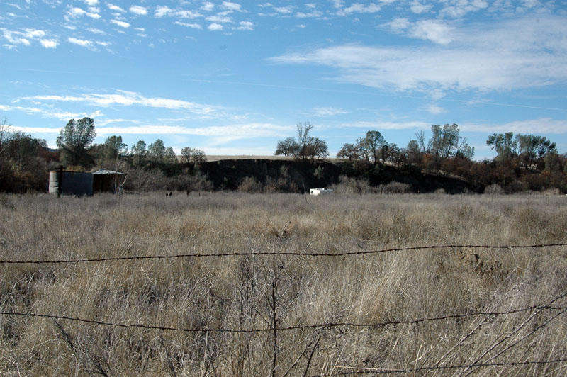
That white rectangle is a camper trailer, and the ridge behind it is maybe 100 feet higher than the trailer side of the fault.
Back to 101, was surprised to see a whole area of working oil rigs and storage tanks. I was still thinking of taking Hwy. 198 to Coalinga and then on to I-5, but passed that exit with too little gas left, and it didn't look like there would be any before I ran out, so I went on to King City and put in enough to get home on. I took advantage of the open Denny's and had lunch, and also took some photos for ![]() bigcatroary's family to use as they will, including this one:
bigcatroary's family to use as they will, including this one:
On the road again, I took some photos of the Soledad exits (who knew there was a center set aside just for teachers to grade papers?)
About 10 miles south of SJ, an inversion layer hit so hard, wood smoke, that I had to close the vents and turn on the heater and air conditioner to be able to breathe. This lasted most of the way through SJ.
Looking at the USGS web site, I was a few hours late for a small quake:
A microearthquake occurred at 10:56:54 AM (PST) on Monday, December 25, 2006.
The magnitude 1.9 event occurred 1 km (1 miles) SW of Parkfield, CA.
The hypocentral depth is 11 km ( 7 miles).
The whole set of photos of the trip can be found here.
Hayward Fault
Date: 2006-12-26 12:57 pm (UTC)I was going to mention the Fremont viewing hole for the Hayward fault, but I see the exhibit is now closed. Interesting reading here...
http://www.msnucleus.org/haywardfault/seismic3.htm
I much prefer living 3000 miles from the faultlines.
George
no subject
Date: 2006-12-26 05:53 pm (UTC)And population 18. My goodness. We do have some tiny little settlements in the Central Valley, don't we?
I remember as a kid getting a photo taken at Point Reyes with one foot on the continental plate and the other on the Pacific plate. Heh.
Thank you for letting me come along vicariously on your journey.
no subject
Date: 2006-12-26 05:56 pm (UTC)no subject
Date: 2006-12-26 05:56 pm (UTC)no subject
Date: 2006-12-27 06:36 am (UTC)